
SAN ANGELO, TX — The National Weather Service in San Angelo issued a Flood Advisory Saturday night for portions of west central Texas, including Irion, Schleicher and Tom Green counties, due to minor flooding from excessive rainfall.
The advisory, issued at 9:16 p.m. CDT, remains in effect until 12:30 a.m. Sunday. Doppler radar showed heavy rain from thunderstorms, with 0.25 to 0.75 inches already fallen in the advisory area and another 0.25 to 0.75 inches expected. Minor flooding was ongoing or imminent in low-lying areas and poor drainage spots, with water likely over some roadways.
Affected locations include southern portions of San Angelo south toward Christoval, Knickerbocker, Twin Buttes Reservoir, Lake Nasworthy and Goodfellow Air Force Base. Low-water crossings at risk include the Mineral Wells crossing of the South Concho River and the Door Key crossing of Pecan Creek.
The Tom Green County Sheriff’s Office echoed the warning in a public alert, urging residents to avoid flooded areas and low-water crossings.
A separate Special Weather Statement issued at 9:24 p.m. warned that strong thunderstorms would continue impacting northeastern Schleicher, southeastern Tom Green and west central Concho counties through 10:15 p.m. At 9:24 p.m., radar tracked the storms along a line from near Harriet to near Christoval, moving southeast at 30 mph. Hazards include wind gusts up to 40 mph and pea-sized hail.
Locations impacted include eastern San Angelo, Christoval, Mereta, Veribest, Wall, Vancourt, Eola, Goodfellow Air Force Base, Vick, Adams and the intersection of U.S. 190 and Ranch Road 2084. Gusty winds could knock down tree limbs and blow around unsecured objects, while minor hail damage to vegetation is possible. Frequent cloud-to-ground lightning was also occurring; officials advised seeking shelter inside a building or vehicle.
The National Weather Service noted that the main concern remains locally heavy rainfall, though very small hail and gusty winds are possible with the storms.
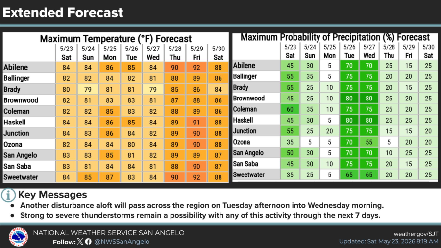
An extended forecast from the NWS indicates chances for showers and thunderstorms will continue through the weekend and into next week, with the highest rain chances Saturday and again Tuesday into Wednesday. Another disturbance aloft is expected to pass across the region Tuesday afternoon into Wednesday morning, when strong to severe thunderstorms remain possible. Temperatures will generally stay below normal into early next week.


")
Subscribe to the LIVE! Daily

Required
Post a comment to this article here: